Our Greenways
Explore Over 300 Acres Across 12 Greenways
What are Greenways?
A greenway is a permanently conserved, primarily passive open space that is stewarded primarily by the community and serves to benefit adjacent neighborhoods and the general public. Greenways connect our communities physically by enhancing movement of people and wildlife. Greenways provide a very tangible opportunity to create, steward, and enjoy a shared urban asset, serving as places where neighbors come together to improve their communities.
Today, the City has 12 existing greenways comprising over 300 acres of public land and 14% of Pittsburgh’s public open space. An additional 21 greenways will be designated in 2026, adding over 3,000 acres to the greenways system. To put this into perspective, Pittsburgh's largest park, Frick Park, is 644 acres.
History of Greenways
In 1980, a "Greenways for Pittsburgh" program was established to consolidate steeply sloped, unbuildable land for the purpose of protecting hillsides and preserving passive open space. With limited resources, the City needed a strategy to protect sensitive hillsides from low-quality opportunistic development, illegal dumping, and environmental degradation. The program created a new designation of public open space, allowing for groups of contiguous vacant parcels, typically along hillsides, to be permanently conserved and primarily exist where environmental conditions are unsuitable for development.
In 2013, the City adopted an Open Space Plan, which recommended a "Greenways for Pittsburgh 2.0" and resulted in the development of a Greenways Policy Guide and Greenways Resource Guide in 2017 (located in the document library on this page). The public process for the Open Space Plan showed a desire for more greenways, access to trails/natural areas, greater connectivity of the open space network, as well as the protection of existing natural areas not designated as greenways. The designation of greenways is an implementation of the plan's objective to "incorporate steeply sloped lands, view corridors, and scenic viewpoints into the open space system as greenways, or protect them through regulatory means."
The Greenways for Pittsburgh 2.0 project was intended to create policy with the goals of fostering stewardship, improving the quality, connectivity and accessibility to these open spaces, as well as striving for the highest level of sustainability in regards to conservation, green infrastructure and maintenance. These goals of the program remain today. The future designation and continued stewardship of greenways will serve to meet the public need and desire for proximate open space.
Our Greenways
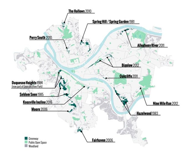
Allegheny River Greenway
Location: 4601-4607 Amsterdam Ave, Pittsburgh, PA 15201
Allegheny River Greenway is located in the Upper Lawrenceville, Stanton Heights and Morningside neighborhoods. A portion of the greenway can be accessed via Amsterdam Ave in Stanton Heights but most of land is currently a passive conservation greenway. There has been ongoing ecological restoration work occurring in several parts of the greenway.
Bigelow Greenway
Location: Stockholm Street and Haran Street, Pittsburgh PA, 15219
Bigelow Greenway is located on either side of Bigelow Boulevard spanning the length of the Hill District and ending in Polish Hill and North Oakland. There are short, unofficial trail networks in a few areas of the greenway such as off of Stockholm Street leading into West Penn Playground and off of Melwood Ave and Gold Way in North Oakland.
Fairhaven Greenway
Location: 2772-2798 Belleville St, Pittsburgh, PA 15234
Fairhaven Greenway offers a 0.7-mile main trail loop with several smaller trails spawning off of the loop. A trailhead can be accessed on the corner of Belleville Street and Norva Street in the Overbrook neighborhood.
Hazelwood Greenway
Location: Longview St, Pittsburgh, PA 15207
Hazelwood Greenway is Pittsburgh’s largest greenway comprised of around 183 acres of green space. The greenway features several miles of trail networks and ecological restoration areas. Community members use the greenway for snowshoeing, hiking, environmental education, tree plantings, and research partnerships.
Knoxville Incline Greenway
Location: 2-98 Welsch Way, Pittsburgh, PA 15203
The Knoxville Incline used to be an the longest (in length) operating funicular transporting passengers and freight up and down the steep hillside. Decades after its closure, and due to major community efforts, the former transit corridor has been transformed into a greenway featuring a number of walking trails, city steps, and a scenic overlook.
Moore Greenway
Location: 1801 Pioneer Ave, Pittsburgh, PA 15226
Moore Greenway features a main 0.8 mile out-and-back, generally flat trail starting from the soccer field parking lot in Moore Park. Several smaller trails of varying condition exist within the wooded area east of the soccer field. Trails can also be accessed via Herman Drive and Timberland Avenue surrounding the park in the Brookline neighborhood.
Oakcliffe Greenway
Location: Lawn Street, South Oakland, Pittsburgh, PA 15213
Oakcliffe Greenway lies along a steep hillside between the South Oakland neighborhood and Interstate 376. There is a short and steeply sloped walking path that can be accessed via Lawn Street, visitors are encouraged to use extreme caution when accessing the trail. The Oakcliffe Community Garden is also nestled into the greenway at the corner of Lawn Street and Elsinore Street.
Nine Mile Run Greenway
Location: Nine Mile Run Trail Parking, Pittsburgh, PA 15218
Nestled into Frick Park, Nine Mile Run Greenway was a brownfield reclamation project that started in the late 1990s. Since then, there have been countless of City, community and nonprofit efforts to maintain trails, restore the ecosystem and stream and create passive and active recreation opportunities. The greenway features extensive walking paths of varying difficulty, mountain biking trails and seating areas. The greenway can be accessed via a parking lot off of Commercial Street in Swisshelm Park as well as via the Lower Frick Play Area parking lot in Regent Square.
Perry South Greenway
Location: 46-58 Strauss St, Pittsburgh, PA 15214
The Perry South Greenway primarily lies within the North Charles Street Valley along Strauss Street in the Perry South neighborhood. Dedicated community-led efforts resulted in a portion of the greenway being activated with a trail, tree plantings, invasive species clearing, interpretive signage, and seating areas.
Spring Hill/Spring Garden Greenway
Location: 1498-1400 Romanhoff St, Pittsburgh, PA 15212
Spring Hill/Spring Garden Greenway runs along the border of the Spring Hill and Spring Garden neighborhoods from Spring Hill Park down to and slightly past Spring Garden Park. Trails can be accessed in the northern portion of the greenway via Romanhoff Street and Schubert Street.
Seldom Seen Greenway
Location: 970 Saw Mill Run Blvd, Pittsburgh, PA 15220
Seldom Seen Greenway is comprised of about 100 acres of green space featuring several miles of trails, the historic Seldom Seen archway, the Saw Mill Run stream, and passive open spaces. Trails can be accessed from the main trailhead off of Saw Mill Run Boulevard as well as through Tropical Park on Tropical Ave.
The Hollows Greenway
Location: Perry North, Pittsburgh, PA 15214
The Hollows Greenway is an 18-acre conservation greenway located just north of Riverview Park in the Perry North neighborhood. There are no formal trail networks, and the primary function of the conservation greenway is protecting and restoring its landslide prone hillsides.
Join the Greenways Stewardship Network! Sign-up for the volunteer email list to connect with greenway stewards from across the region by reaching out to: greenways@pittsburghpa.gov.